San Marcos River Tubing Rafting and Kayaking

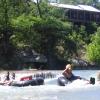
Float Down the San Marcos River

All About the San Marcos
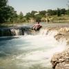
The San Marcos river is a host some of the cleanest water you can find, anywhere. The water from its spring-fed source is 10 times cleaner than EPA standards for drinking water!

The usual float is one mile, though it's possible to float longer with a do-it-yourself toobing trip. When you're done, you can make a quick 10 minute walk back to the beginning and toob it again, or catch a shuttle back, operated by the Lions Club of San Marcos.

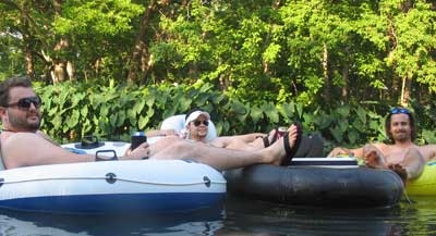
Toobing the San Marcos River

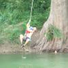
The river is stunningly protected from development. You can toob right through part of Texas State campus, downtown San Marcos, but you'll feel like you're in a nature preserve. Most of toobing part of the river is park land on both sides. Huge elephant ear plants line the banks. A native (and endangered) wild rice grows in the cool, clear waters.

San Marcos River Toobing

If you've never toobed the San Marcos river, you should. It's much like the Comal, but less crowded, and less fuss.

There are plenty of wide easy stretches to the river, and the clarity is great. Spring fed, this short gem was made for floating. The river is a constant 72 degrees.

San Marcos River Tubing Companies

The Lion's Club operates the only shuttle.

More San Marcos Tubing Info

If you put in above the Lions club, you'll encounter a group of guys that will dive-bomb you! Be careful! (But of course it's all in fun!)

Access points for DIY toobers

Most toobing trips will start at Lion's Club, and end at Rio Vista, or CR 299. Access points after that are for reference only / kayaking.

  • Concrete walkway adjacent to the Lions Club tube rental facility in Old City Park at 0.0 miles
  • Rio Vista Dam at 1.0 mile
  • CR 299 at 2.0 miles
  • CR 266 / CR 101 at 5.5 miles
  • Pecan Park Retreat (Private campground) at 6.0 miles
  • Sculls Crossing (off CR 103) at 9.2 miles
  • FM 1979 at 11.5 miles
  • FM 1977 (just above Staples Dam) at 16.5 miles - this is the usual end of trips for less experienced paddlers
  • Fentress (SH 20) low-water crossing at about 25.5 miles
  • Prairie Lea (CR 280) low-water crossing # 1 at about 28.5 miles
  • Prairie Lea (CR 116) low-water crossing # 2 at about 31.5 miles
  • Stairtown (CR 119) crossing at about 32.5 miles
  • US Highway 90 crossing at about 39.0 miles
  • Luling City Park on river left at about 45.0 miles

Access is adequate at most crossings, but the availability of public parking is very limited. Please be considerate of others when accessing the river, and always park your vehicles where they do not block river access for others. Never park on or enter private property without securing permission from landowners.